
Culvert Removal-Bridge Installation
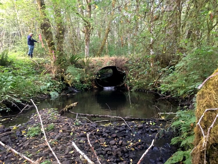
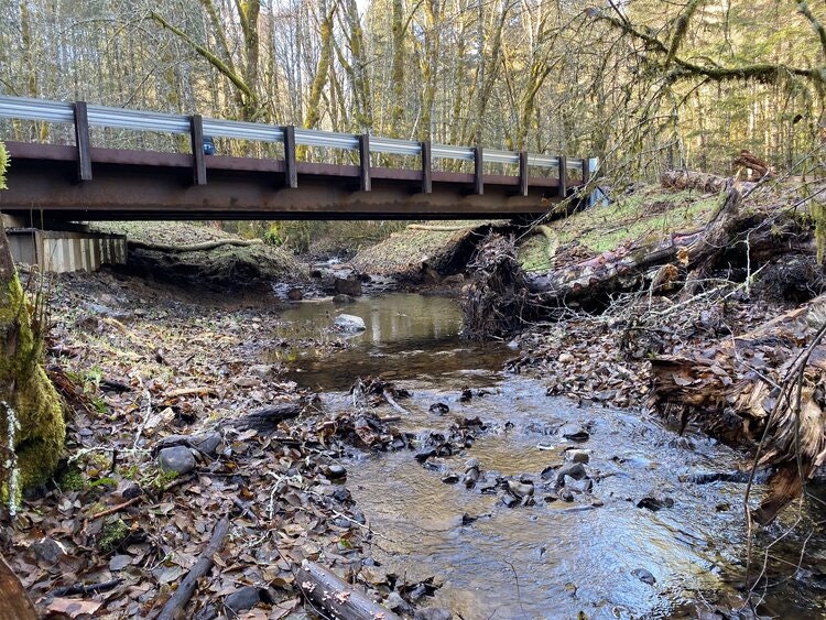
Project Description: John Hancock Forest Management (JHFM), in partnership with the Columbia Soil and Water Conservation District (CSWCD) removed a 60-inch culvert associated with the W146 access road in Columbia County, Oregon, that crossed an unnamed tributary of the Clatskanie River. The culvert was replaced with a bridge spanning 55 feet that supported an active channel width of 23.5 feet. The crossing of the unnamed tributary by the W146 access road is roughly located 2,000 feet upstream from the stream’s confluence with the Clatskanie River.
The Clatskanie River and its tributaries provide habitat for Endangered Species Act (ESA) listed Coho salmon, as well as winter steelhead and other important aquatic species. The unnamed tributary crossed by the W146 access road contains quality fish spawning and rearing habitat, however, before replacement the previous undersized and perched culvert acted as a barrier to approximately 1.7 miles of Coho habitat and almost one mile of steelhead habitat. Thus, the Oregon Department of Fish and Wildlife (ODFW) had identified the culvert as a priority for removal. In addition, replacing the culvert required the protection of a wetland complex, that was immediately adjacent to the project area, associated with the unnamed tributary. Wetlands provide important rearing habitats for young fish as well as refuge from high flow events, especially during the migration of young salmon.
As a result of the partnership between CSWCD and JHFM, the CSWCD applied for and obtained Oregon Watershed Enhancement Board (OWEB) grant funding to implement the project to replace the culvert using a bridge design developed by a JHFM contracted engineer. The CSWCD managed the OWEB grant funding and hired Aquatic Contracting to implement the project. Subsequent replacement of the culvert with a bridge in September 2019 resulted in the restoration of a natural channel and flow processes through the W146 crossing that effectively opened up fish access and increased vertical and horizontal water level capacity that will accommodate some natural lateral channel movement through the crossing alignment. Replacement of the undersized culvert with a bridge will also allow the previously restricted stream sediment transfer and deposit regime to reset as movement of material will resume. During the course of the project protection of the wetland was imperative in order to ensure this important habitat associated with the stream was retained. Awareness of this sensitive habitat throughout the project process, from design to implementation, resulted in avoidance of impacts.
Project Details: Project implementation commenced on September 9, 2019, in conjunction with a pre-construction meeting, with final work completion accomplished over September 30-October 4, and October 7-9. Pre-construction work started with mobilization of equipment to the project site and delivery and stockpiling of rock and other necessary materials. Stream channel in-water work isolation and initiation of flow bypass to dewater the in-water work area occurred on September 13th. Fish salvage was also conducted on September 13th while dewatering occurred. Clearing of the areas within the footprint of bridge construction occurring the following day on September 14th. Delivery of the bridge and its accessories occurred on Monday September 16th. Due to heavy rains work was suspended on September 17th and 18th. Work commenced again on September 19th with the removal of the overburden around the culvert, and then the culvert. Following that process, an inset floodplain and stream channel that matched the surrounding natural setting and stream grade and geomorphic features was recreated through the area where the culvert was previously located, and nearby sourced streambed simulated substrate was placed. This work was followed by flow bypass termination and re-watering of the re-created channel. Additionally, the slopes adjacent to the stream’s floodplain were sloped back to the existing road grade.
Over September 20-21, the bridge abutment bins were placed and filled with rock according to construction specifications. With the bins in place, over September 23-27 the bridge deck was placed and constructed, and scour protection rock was installed (per construction specifications) along the exposed areas of the abutments. Trees salvaged from clearing areas within the footprint of the bridge, a couple still with root wads intact, were also placed to add complexity and structure in the newly re-created in-set floodplain immediately adjacent to the channel. Similarly, salvaged trees were placed in the retained wetland 2 immediately west of the bridge approach. The inset floodplain, large wood, and nearby sourced streambed simulated substrate and boulders will allow the unnamed stream to move and adjust its course naturally as these materials were placed in a manner that will not lock the channel into a specific alignment.
Final work completion was accomplished over September 30-October 4, and October 7-9, with the final layers of rock placed on the portion of access road within the project footprint, project clean up and stabilization (covering) of exposed soils with slash and straw to minimize erosion in the near term, erosion control grass seeding to establish rapid cover for longer term erosion control, and removal of equipment from the project site. Areas immediately adjacent to the access road to the project were also covered straw to further minimize erosion. Late fall 2019 or early winter 2020 riparian plants will be installed along the stream and slopes in the project footprint to facilitate long term soil stabilization-erosion protection and to jump start the re-vegetation process.
This project is a great success. The removal of the culvert opened up 1.7 miles of Essential Fish Habitat (EFH) for Coho habitat and almost one mile of EFH for steelhead, and allows for the migration of other numerous important aquatic species. The stream will be monitored by the Columbia SWCD over a three-year period to watch how the recreated channel adjusts. It is anticipated that changes will be observed as depositional and erosional forces transport streambed material, and water acts on the wood added to the inset floodplain, creating geomorphic features akin to the rest of the unnamed streams system.